

Dike route 2
Dike routes 1 & 2 take you through the history of 'Living with the water'. Pumping stations, dikes and sluices together with monuments tell a story of struggle against and living together with rivers and tides. Route 2 leads you along Hank - Nieuwendijk - Fort Bakkerskil - Werkendam and the Steurgat.
This dike route lets you experience the interplay of water, history and nature. From the Dutch Waterline to the Biesbosch: you travel through a landscape from which the Netherlands derives its identity. A trip full of contrasts, silence, and impressive vistas. Hank - gateway to the Biesbosch You start your tour in the quiet Brabant village of Hank, which lies right on the edge of National Park De Biesbosch . Hank has a small-scale and rural character. From the edge of the village you can see the polder opening up: wide meadows with ditches, pollard willows and rows of poplars. Along the Buitendijk, you immediately feel the influence of the water: you drive above the landscape, overlooking marshy meadows, swans and geese foraging at leisure in the ditch banks. You are in the transition area from cultivated land to nature reserve. Nieuwendijk - along creeks and wetlands The ...
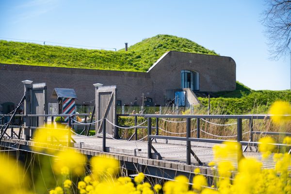
This dike route lets you experience the interplay of water, history and nature. From the Dutch Waterline to the Biesbosch: you travel through a landscape from which the Netherlands derives its identity. A trip full of contrasts, silence, and impressive vistas. Hank - gateway to the Biesbosch You start your tour in the quiet Brabant village of Hank, which lies right on the edge of National Park De Biesbosch . Hank has a small-scale and rural character. From the edge of the village you can see the polder opening up: wide meadows with ditches, pollard willows and rows of poplars. Along the Buitendijk, you immediately feel the influence of the water: you drive above the landscape, overlooking marshy meadows, swans and geese foraging at leisure in the ditch banks. You are in the transition area from cultivated land to nature reserve. Nieuwendijk - along creeks and wetlands The route continues towards Nieuwendijk. Between Hank and Nieuwendijk agricultural areas and nature alternate. You follow a narrow dike with beautiful views of old creeks and marshy natural areas. Nieuwendijk is an elongated ribbon village with a mix of modern homes and older farms. In the verge here and there are fruit trees and blooming flower borders. A nice moment of rest is at a bench at the edge of the village, where you look out over a marsh area with reeds and willow forest. Fort Bakkerskil - heritage in the greenery After Nieuwendijk you come to one of the most beautiful historical points of the route: Fort Bakkerskil. This 19th-century fort was part of the Nieuwe Hollandse Waterlinie, a line of defense that used inundation (deliberate flooding). The fort is idyllically hidden among trees and has a moat surrounding it. You can dismount here and view the grounds. It is a unique combination of cultural history and nature experience. Check the website for catering opening hours. Werkendam - dike landscape and river plain The route continues towards Werkendam, a somewhat larger town on the edge of the Biesbosch. Here you cycle along dikes with wide views of polders, natural areas with ponds, reed beds and willow thickets. Werkendam is the historic home of the Biesbosch fishermen and wickerworkers. Here you can feel the water life: boats in the harbor, shipyards and rows of houses along the water. In the center you can pause at a lunchroom or café. If you have time, it pays to visit the Biesbosch MuseumEiland in the middle of the Biesbosch. The museum provides fascinating insight into water life of the past and present. Steurgat From Werkendam you cycle towards the Steurgat - an arm of the river that forms the connection between the New Merwede and the Amer. This part of the route is impressive: you ride over the dike, high above the water line, with the river on your right and the Biesbosch on your left. Here you see colonies of geese, herons, sometimes even a bald eagle. Ships slowly pass by. The Steurgat is wide, open and powerful - a classic Dutch river scene. In clear weather, you can see the outline of Gorinchem or the Amer power plant in the distance. Back via dikes and polder roads After the Steurgat, the route bends back towards Hank. You cycle again over dikes, along canals and wide arable land. Nature is soothing and varied here. Sightlines with willows, the occasional deer or buzzard, and many farmyards with flower strips and hay bales. The route ends where you started - in Hank - with a sense of peace, enrichment and connection to the water landscape.
What you will see
-
Docks Vissershang
Docks Vissershang (Stop 1 – Starting Point)
Vissershang 2
4273 PE Hank
Navigate to starting point
-
18
-
19
-
20
-
30
-
22
-
Tims Touch by Waterman Culinair
Tims Touch by Waterman Culinair (Stop 5)
Vierlinghstraat 1
4251 LC Werkendam
-
12
-
Docks Vissershang
Docks Vissershang (Stop 6 – Final Stop)
Vissershang 2
4273 PE Hank
Navigate to destination


- 18
- 19
- 20
- 30
- 22
- 12